
Article Expired.
- Posted: 01/06/2015 9:15 AM
- Article Expires 6:00 PM, 1/06
- This is a Weather Discussion and NOT a forecast
Ice Storm Looming on the Horizon for Piedmont NC!
After brief warm up into the upper 30’s Friday and Saturday, another shot of cold air filers in from the northeast Saturday night and Sunday morning. A coastal Low develops off shore about the same time as a Baja California low comes up through Georgia and the Carolinas. These two systems MAY phase together giving us a good shot at winter precipitation.
There is little model agreement on timing and precipitation type (P-type) however the Medium-range models do agree on temperature.
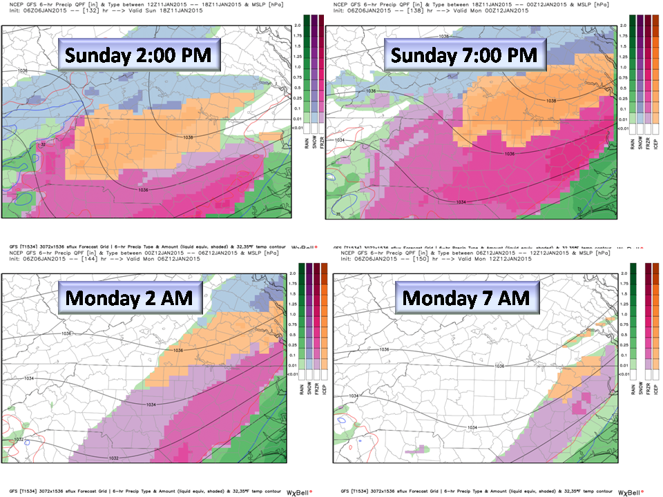
- Enhanced GFS: shows the best scenario at this time with a thermal profile leading towards a Wintry Mix with the predominate P-type being Freezing Rain. Snow is also indicated in the GFS but this is weakly supported in its ensemble members.
- European: Gives the Piedmont a significant snowfall and is nearly 24 hours later. The Euro has been doing better now that the SE ridge is weakening but it is still adjusting with precipitation.
This is the likely scenario for the Piedmont as of this writing and accounts for thermal profiles and precipitation amounts (QPF).

Should more cold air filter in through the Mid-levels of the atmosphere, the primary P-type would turn to Snow and have us running for Milk and Bread. This is again, NOT the favored solution right now but may change in later model runs. BUFKIT soundings indicate a surface temp below freezing but with above freezing air aloft…this profile does not produce snow. Here is an image of that scenario just in case you are interested.

The Bottom Line:
Prepare now for the cold and then make plans for winter weather Sunday and Monday. All NWS offices are discussing the development of this winter storm and officially, Confidence is Low without more consensus from Medium-Range models. Short-range models will begin picking this system up in the next couple of days then confidence will increase.
Emergency Manager Statement: If you are a First Responder or Emergency Manager please take note and share so that staffing and resources can be allocated should this become a major event.
NC Weather Happens. Enjoy it!
Receive articles like this in your email by subscribing at ncwxhappens.com and follow us on Twitter @ncwxhappens