Follow this, and other content on ncwxhappens.com …remember Facebook changes all their distribution rules on the 1st!
Through this weekend, the weather will be mild enough to walk off those Holiday calories!
Discussed before, our region is under the influence of High Pressure off coast of Florida. This is pumping in warm south Atlantic air keeping us mild for this time of year. Look for that to change New Years day.

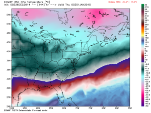
New Years Chill:
The European and GFS models agree on this cool down with lows in the low 20’s and highs struggling to get above freezing. Little chance for precipitation shown at this time.
Temps will climb back towards normal on the 4th and is being watched closely as a low pressure system advances on the region… all about timing.
Looking ahead for January:
We are looking at near normal temps but there are 2 really good winter weather opportunities that pop out of the model around the 12th – 14th and then again on the 21st.
We aren’t seeing brutal cold in the long-range as the enhance Pacific ridge is training warm pacific air and storms into the southeast and blocking arctic cold via the Southern Jet Stream. There are indicators now showing that this pattern will be changing in the long-range bringing the second half of January below normal for temps but we have to see how those indicators develop over the next few days to see how they may affect our area.
NC Weather Happens. Enjoy it!
Follow this, and other content on ncwxhappens.com …remember Facebook changes all their distribution rules on the 1st!

