

This is a quick update before our Winter Storm arrives this evening.
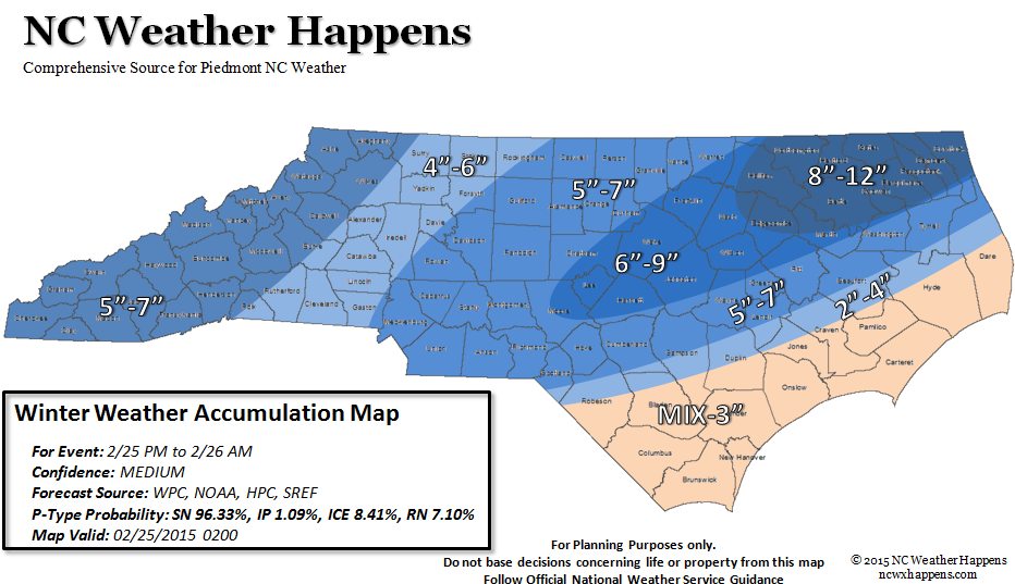
First off, the map looks a little different. What we have seen in the last few model runs and Radiosonde data, is a really weakening High Pressure which has kept us in the cold. As such, when the storm arrives there will be much more time with rain before a change-over to all snow. The Coastal Plain will see more of a mix with their accumulations but with more in the way of Rain, their totals have been decreased (in this map).
The Central Piedmont from the Triad to the Triangle stands to see the most accumulation with the exception of a pocket in the NW Coastal Plain with impressive snowfall amounts. The bulk of the precipitation will fall East of the Appalachians into the Piedmont which is why we see a small decrease in accumulation between the Mountains and Western Piedmont.
Obligatory Disclaimer:
For the Probability lovers, there is nearly a money back guarantee that everyone in the will see snow (90%)! For the 90% guarantee, the Piedmont, will see 2-4 inches of snow and that can be taken to the bank. On the outside, this map may be underdone and you can add 3 or more inches tot he displayed totals but there is only a 25% chance of that happening!
At this time, we feel this map best represents what we are seeing in the guidance available. Anything more would be wishing it to happen.
NC Weather Happens. Enjoy it!
Be sure to get articles like this in your email by subscribing at ncwxhappens.com…its Free, No ads, and No spam but more importantly, No delay! We are also on Twitter @ncwxhappens.
If you are interested in advertising on this high volume webpage, please send us a note and we’ll send you some information.