
ARTICLE EXPIRED. CLICK HERE FOR UPDATE.
Without going into all the details of what is bringing us a Winter Storm, we’ll just cut to the chase and let you know what to expect. Keep in mind the track of this approaching storm is still very much in play as well as available moisture (QPF) and timing, so don’t get locked into “How much” or “Where”. Suffice it to say that the whole of North Carolina will likely receive accumulating snow, enough to close schools, and disrupt any travel and that is more important.
Temperatures:
- Tuesday Night: we should dip into the mid 20’s and areas that received an inch or more of snow today, may dip more towards 20. Whatever falls today will stick around.
- Wednesday: With a “snow pack” in place we will struggle to get out of the 40’s and there is only a short window in the early afternoon before clouds moves in ahead of our approaching system keeping temps down.
- Wednesday Night: Snow should enter the Piedmont from the Southwest between 5:00 and 7:00 PM and last through the night.
- Thursday: Snow should end Southwest to Northeast by daybreak.
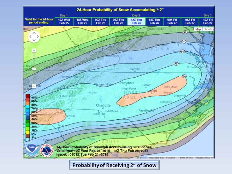
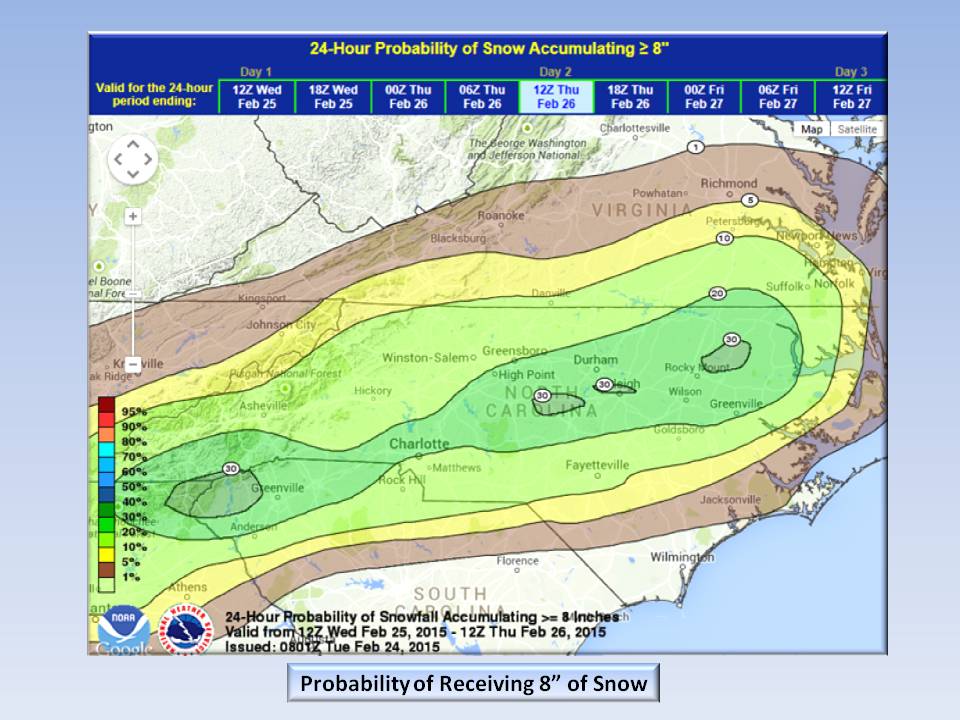
Probabilities:
You’ve seen these floating around the Internet, so we’ll just post them again for reference. The probabilities for 1″, 2″ 4″, 6″, and 8″ snow accumulation.


Accumulation:
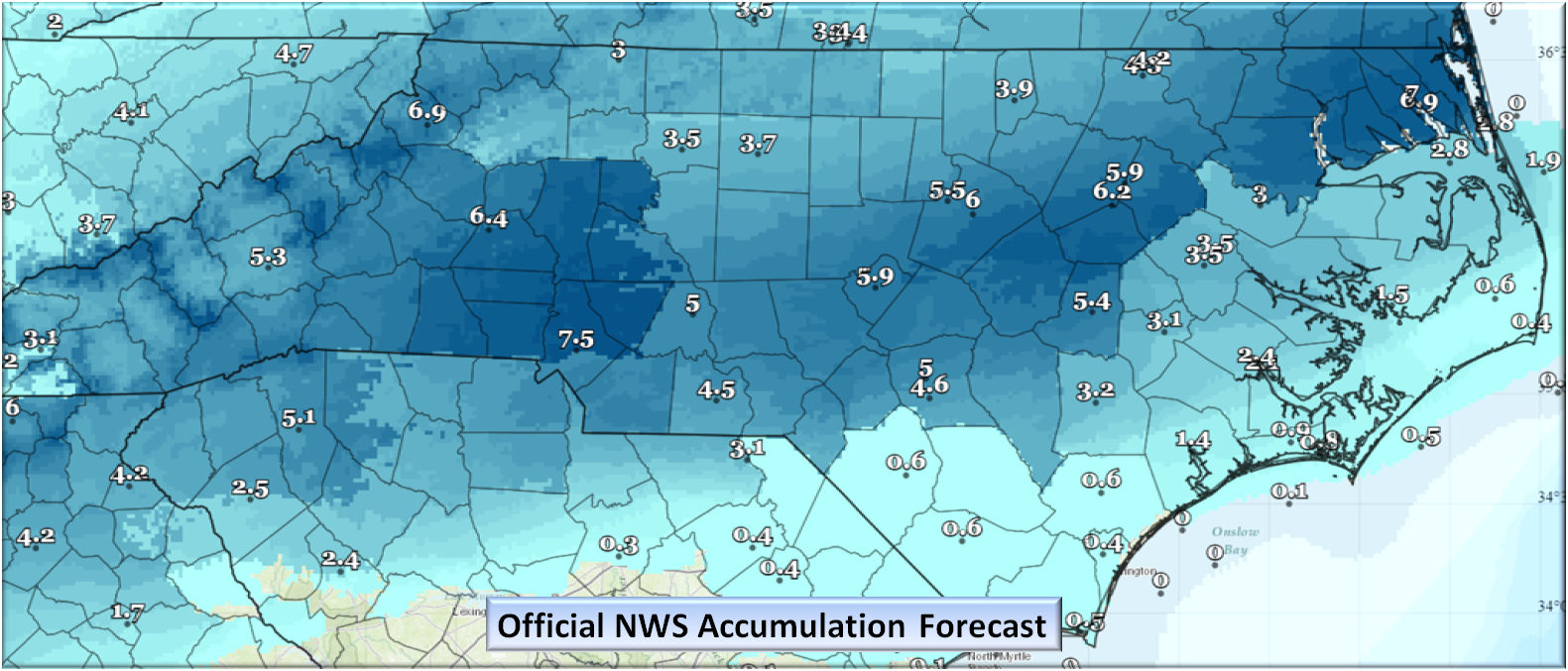
At the time of this writing, this is the Official Accumulation Guidance from NOAA.
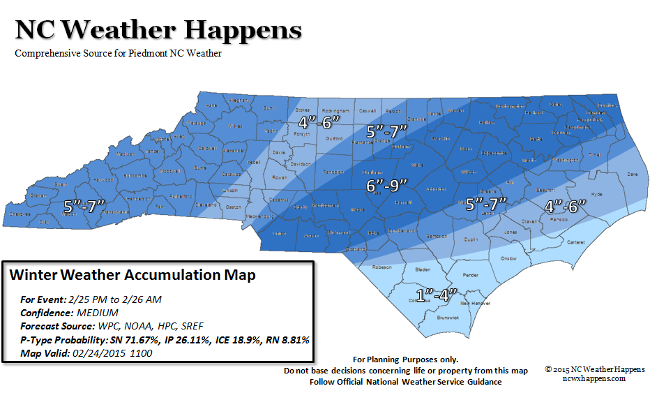
Here at NC Weather Happens, we have taken the above information and made our own accumulation map.
Considering ALL models and their ensembles, more than 5000 data points around the state were entered, then using a GIS, we used Interpolated Distance weighting (IDW) to generate a surface. It was not a pretty map and would confuse everyone. What is shown below is a “clean and polished” version using off the shelf software. So if anyone asks, this is how we came up with the map.

Bottom Line:
Only the National Weather Service can close a school or issue an advisory/warning. Please listen to Local Media for any official guidance.
You can stay informed with any Advisories, Watches, or Warnings here or at http://www.weather.gov/.
There will be a window of opportunity later this evening and tomorrow to get your Milk and Bread so please be prepared as we finally get Winter! Roads today are still treacherous, so stay in if at all possible. A winter Weather Advisory is in effect until 10:00 PM for the Piedmont for road conditions, so be careful!
NC Weather Happens. Enjoy it!
Be sure to get articles like this in your email by subscribing at ncwxhappens.com…its Free, No ads, and No spam but more importantly, No delay! We are also on Twitter @ncwxhappens.
If you are interested in advertising on this high volume webpage, please send us a note and we’ll send you some information.