
Now that we are on solid footing and Spring is well underway, it is time to take a look back on the winter season and review our winter forecast.
As you recall, we released our winter forecast towards the end of October which at the time, had a growing El Nino and all the changes that come with it. To be honest and fair, our forecast was largely a bust…but not really. Here’s why…
Overview – Where we were right:
- Outside of the mountains, the Piedmont and coastal plain really only received 2 snowfall events.
- The forecast made mention that in an El Nino year, we could receive our entire snowfall in one or two events and that is exactly what happened.
- We also reinforced the idea that we would likely see an uptick in the potential for ice which would lower snow totals. Yes, that did in fact occur especially in the Triad and Triangle areas.
- Our temperature profile for the season was perhaps the most accurate as we trended above normal for much of the season.
- Northern tier counties received forecast amounts.
Where we went wrong:
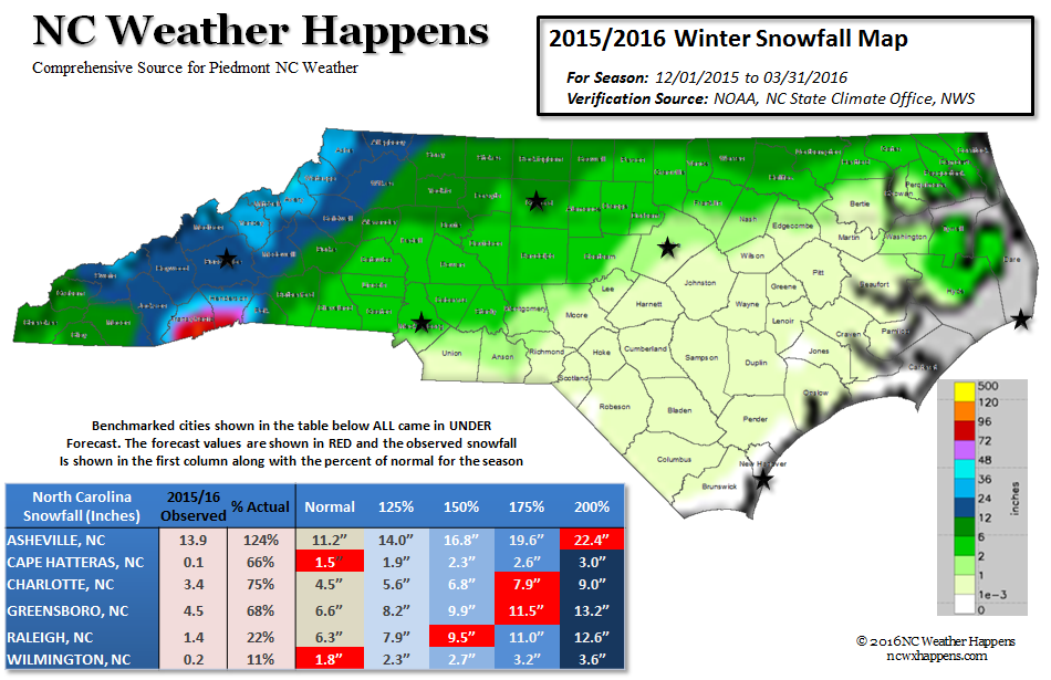
- 5 bench marked cities around the state all received much less than forecast.
- The regions identified on the forecast map ran more SW to NE which in our early analysis, indicated more impacts from nor’easters. The continental trough setup more westward allowing for more Appalachian Wedge type events to occur.
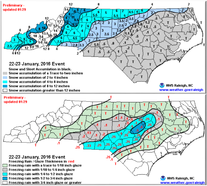
Most of our snowfall fell in one event over January 22 and 23. This was a cold air dam event for North Carolina where areas north received almost unimaginable snow. Here in NC, cold air filtered down the eastern slopes of the mountains wedging in very cold air while a developing nor’easter traveled up the coastal plain from Georgia. In this one event, warm air began to filter into the mid-levels of the atmosphere turning what would have been a snowfall that would have exceeded our forecast, into a sleet and freezing rain from the Triad south and east.
In the Greensboro region, snow changed over to sleet which compacted the snow total. At one point we measured 4.9 inches of snow on the ground. Sleet compacted that amount to 2.2 inches. Had it been all snow, Greensboro would have received closer to 12 inches of snow! We forecasted 13. Greensboro received 1.2 inches of liquid precipitation which would have been 12 inches using the standard 10:1 ratio.
The same occurred in Raleigh where snow changed over to freezing rain and sleet. Areas north and west of Greensboro came in as forecast. Again, this one event would have brought our forecast in statewide and we would be serving champagne… but in NC, that Cold Air Dam is one of the most difficult phenomena to forecast in the winter.
We completely busted on the coastal plain from Cape Hatteras to Wilmington where less than an inch of snow was observed the entire season.
The Bottom Line is we have done better, but still give credit for our disclaimers which suggested Ice would degrade the snowfall totals and that our seasonal totals would be in be or two events. The “Godzilla” El Nino made this one of the most difficult seasonal forecasts we have made…and we own it.
As such, we give ourselves a C+ for the 2015/16 Winter season.
Here’s How We Did:
Lessons Learned:
- For the 2016/17 Season, we will add more benchmark cities to give more geography between the north and south. Boone received its forecast amount, while just south of Asheville (which came in below forecast) received the most in the state with over 2 feet of snow or 400% of normal!
- We received excellent feedback on the format of the forecast and the use of actual amounts rather than %above/below normal. We will use that again moving forward.
- We will also continue to limit the use of jargon and keep things as simple as watching your favorite broadcast meteorologist. This was most appreciated in your comments.
- Grandfather Mountain received a record 68 inches of snow. who could have forecast that!
The 2016/17 Winter Season:
Another difficult winter season is coming this year with our El Nino transitioning into what appears to be an equally impressive La Nina. The winters of 1999 and 2007 come to mind as they were also winters following El Nino… Warm and Dry Autumns with cold and wet winters. A favorite saying from my Weather and Climate professor almost always pans out…”What happens in December, Winter Remembers”. Recall this past December was record-setting warm? Well, we had a mild January and February didn’t we… That darn folklore!
Thanks for following and always remember that…
NC Weather Happens. Enjoy it!
Be sure to get articles like this in your email by subscribing at ncwxhappens.com…its Free, No ads, and No spam but more importantly, No delay! We are also on Twitter @ncwxhappens.
Advertise your business on this high volume webpage. Send us a note and we’ll send you some information.