
NC Weather Happens area of responsibility is Central North Carolina but we have to look globally to see what’s going on.
“All this talk of a brutal winter and all we have is rain…sheesh!”
Mentioned yesterday on Facebook, we said that this comes down to Geography for our area.
- A persistent High Pressure ridge over the Bahamas has been funneling warm moist air up from the Gulf of Mexico into our area for a little over a week now. This is likely to continue for a few more weeks but it is weakening. This weakening will allow cooler air to enter the Piedmont more frequently…but it will still be there until this circulation pattern changes. Meanwhile, there is plenty of cold air…on the other side of the Appalachians!
Check this link to better see how this works. https://www.windyty.com/?surface,wind,2014-12-28-18,35.990,-79.698,4
Checking Greensboro, Charlotte, and Boone climate records for December, we are running about 1-1.5 degrees ABOVE normal. November on the other hand was 3 to 5 degrees BELOW normal. So we are on track and no adjustments are needed for our long-range ideas about this winter.
Models are having a tough time with the very strong enhanced Pacific Jet Stream current which was discussed earlier. This image shows clearly how the Southern Jet is locking cooler air out of the Piedmont but the trend is looking cooler for us in the New Year. Winter is just getting started albeit late!
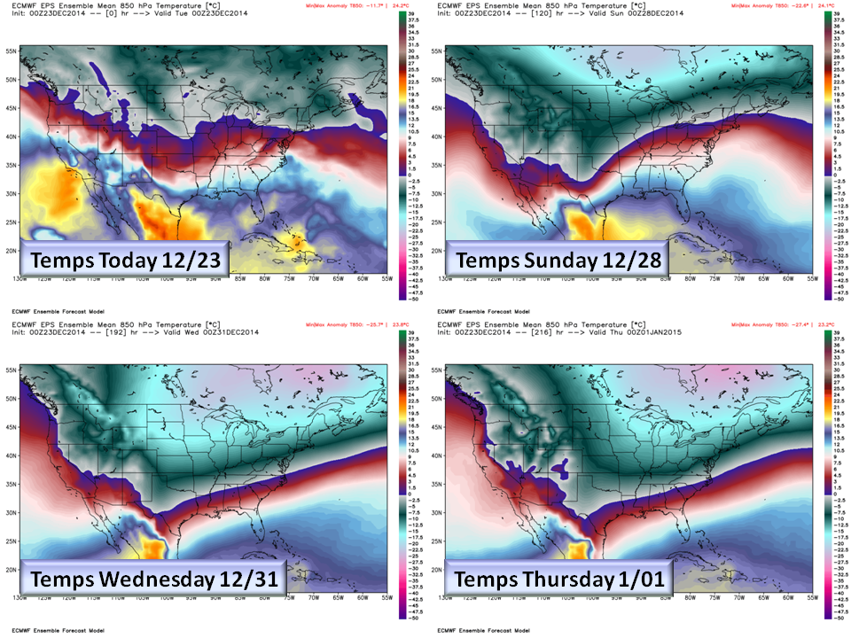
The influence of the “Bahama High” is having a dramatic impact on our winter but we do see it subsiding in the 29th – 31st time frame…as we have been saying now for over a week. This means that the Southern Jet can move more towards our way allowing winter in.
So will it Snow?
- Weakening High Pressure in the Atlantic.
- More eastward track of the Southern Jet Stream.
- Strong High Pressure over the Great Lakes sending cold down into the Piedmont side of the Appalachians.
- Low pressure coming up from the gulf of Mexico
IF ALL THESE THINGS ON THE SNOW MENU COME TOGETHER…YES…More likely a wintry mix at this point. We are still more than a week away but it is beginning to show up now and being discussed in the Raleigh and Blacksburg Weather Service Offices. Here is a look at a one scenario from the new High Resolution GFS model.

We need to get that Great Lake high pressure a little stronger to ensure that cold air is firmly in place and monitor ground temps for any accumulation.
NC Weather Happens. Enjoy it!
Follow this blog at ncwxhappens.com