

We are in a cycle of Highs and Lows…literally. Sooner or later this perpetual bad timing will end and the trends are showing its only a matter of time!
Here at NC Weather Happens, we love the Meteogram. At one glance, all sorts of information can be obtained like rain and snow, temperatures, etc… If you look deeper into them, and without even looking at a map, you can tell get a broad overview of what’s going on. Let’s take a look at one then compare it to a Map.
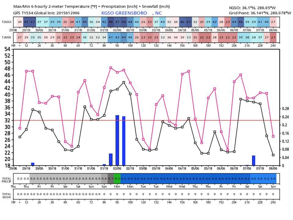
Meteogram for Greensboro taken from the latest GFS model
- The red line running through the middle is the freezing line (32 degrees).
- The pink and black lines are the rang of possible temperatures for that day with the max and min graphed.
- The blue vertical bars are liquid precipitation for that time period with the amounts shown on the far right margin.
- Underneath, the amount or precipitation is shown as an accumulation across the entire sheet. Green is rain. Blue (if it fell) would be snow.
- Underneath rain is snow total.
- Across the top are the minimum and maximum temps for the period (same as the graphed temperature lines).
So what do we see here?
Answer: A Forecast!
- Temps today will be in the upper 40’s with a chance of sprinkles this afternoon and evening. Tonight, we will be cooler with temps at or near freezing. Friday will be not as warm with highs in the low to mid 40’s and Friday night cooling down into the lower 20’s.
- For the weekend, we can see near normal temps with highs in the upper 40’s and lows around 33 degrees. Sunday we can see a good chance of light rain and is expected to be all rain at this time.
- For Monday, rain should end with highs in the mid 40’s. Monday night, temperatures will fall into the low 20’s with teens possible…
This is how we see a Meteogram. Now let’s put is on a map.

Looking at the maps, we’ve placed the Meteogram on the left for the proper time period.
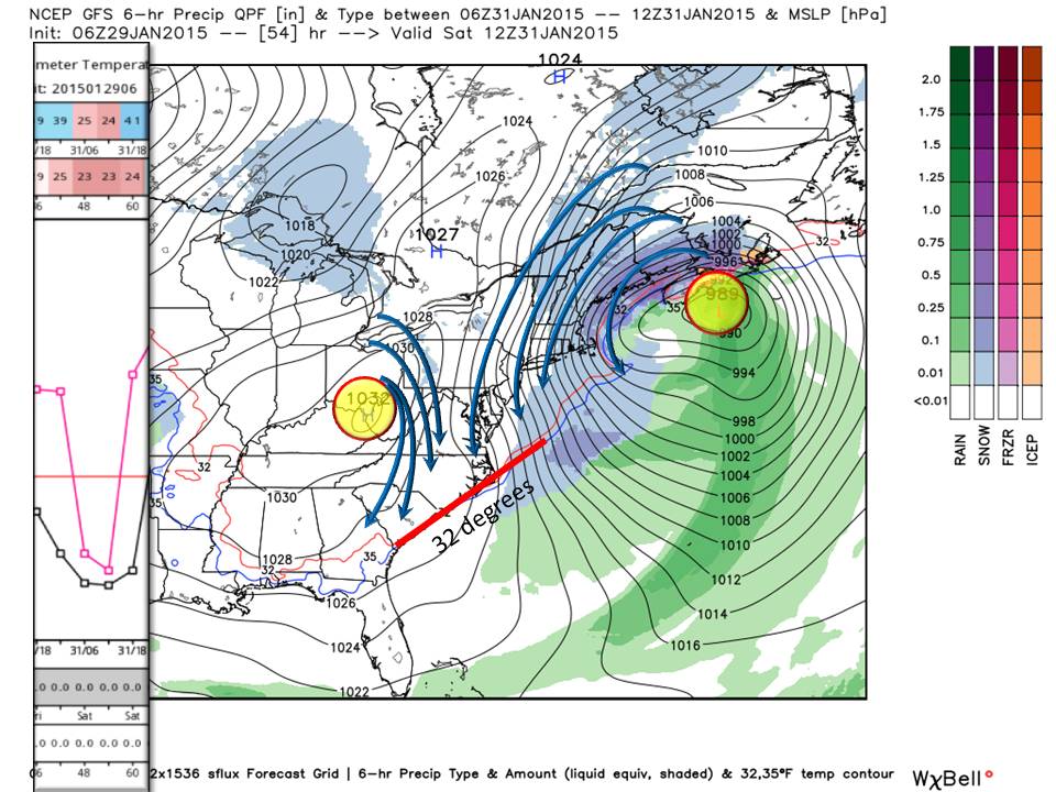
Map 1. We have a cool down as a departing clipper system moves to the northeast. It’s counterclockwise circulation sends cool air down the east coast. Adding to this, a strong dome of High pressure with it’s clockwise circulation funnels dry continental air into the same region. The 32 degree freezing line is shown… This is why the Meteogram shows us having a cold Friday night into Saturday morning. But what happens Sunday?

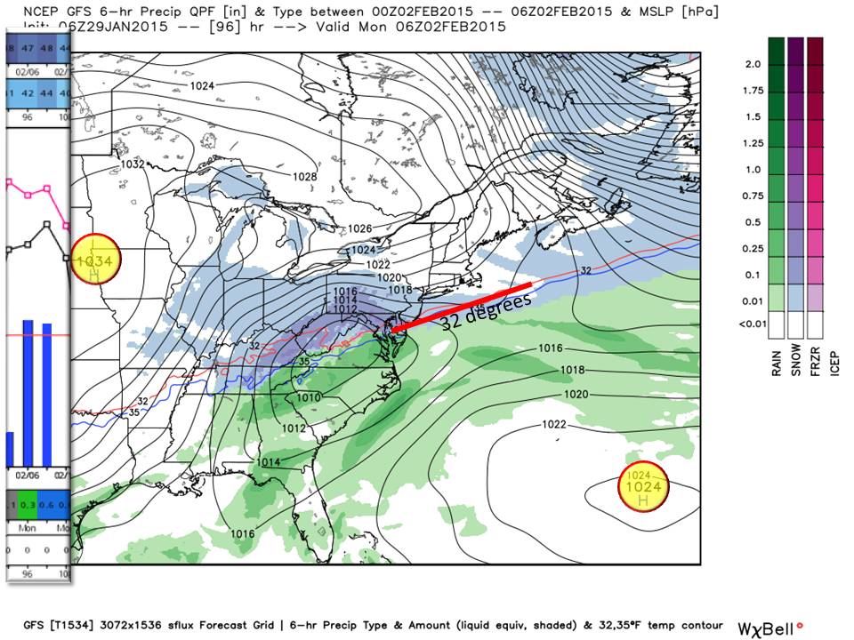
Map 2. Losing the influence of the New England Low, the High pressure moves across the Piedmont and offshore as a Great Lakes High Pressure tries to usher in colder air. The proximity of the coastal High brings out temperatures back above freezing right as a low pressure system from the Gulf approaches. In the map, you can see the temperature line retreating northwestward and the coastal high sending in warm Atlantic air.
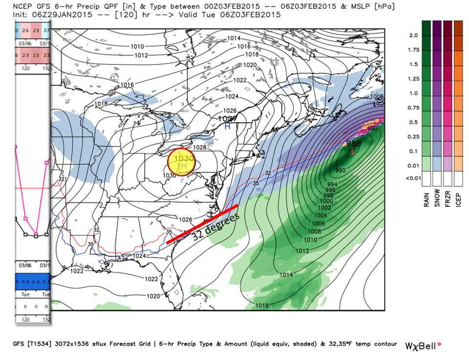
Map 3. As our gulf low strengthens and approaches the area, our coastal High pressure weakens a bit and moves offshore. Meanwhile, a strong High pressure centered over the plains approaches but it’s position makes it so all the cold air piles up on the western face of our mountains leaving us under the influence of the coastal high.
Map 4. Right when all of our precipitation leaves the area, the Plains High pressure moves into a favored area that does send cold air south into the Piedmont.
Our problem all season has been these pesky weak high pressure domes just off the coast sending in warm Atlantic air right when gulf systems arrive. The upper air dynamics, and teleconnections all indicate that we should be seeing a harsh winter…This morning they are indicating that we will also experience winter well into March! January has turned out to be about a degree below normal so far. What will Phil predict for us?
Bottom Line:
Yes this is a very basic synopsis of what is going on and my professor would tell me it is correct, but I need more discussion about the AO, NAO, PNA, etc… They are factored in and we don’t use jargon here! Looking at this time period, you can see there is not much wiggle room temperature wise…so any deviation in strength or position can change this forecast and introduce frozen precipitation (10% chance wintry mix) for Sunday night.
For the remainder of February, continue to keep the 5th through the 7th on your calendar as we have another system (with the same issues as this) approaching. This one will likely bring another strong New England storm…for now we are just watching for model consensus and a trend to emerge for Piedmont forecasting. So sit tight folks, all the indicators are here and they all say winter is on and will be here a while.
NC Weather Happens. Enjoy it!
Be sure to get articles like this in your email by subscribing at ncwxhappens.com …its Free, No ads, and No spam but more importantly, No delay! We are also on Twitter @ncwxhappens.