
Valid: 2/02/2015 until 5:00 PM
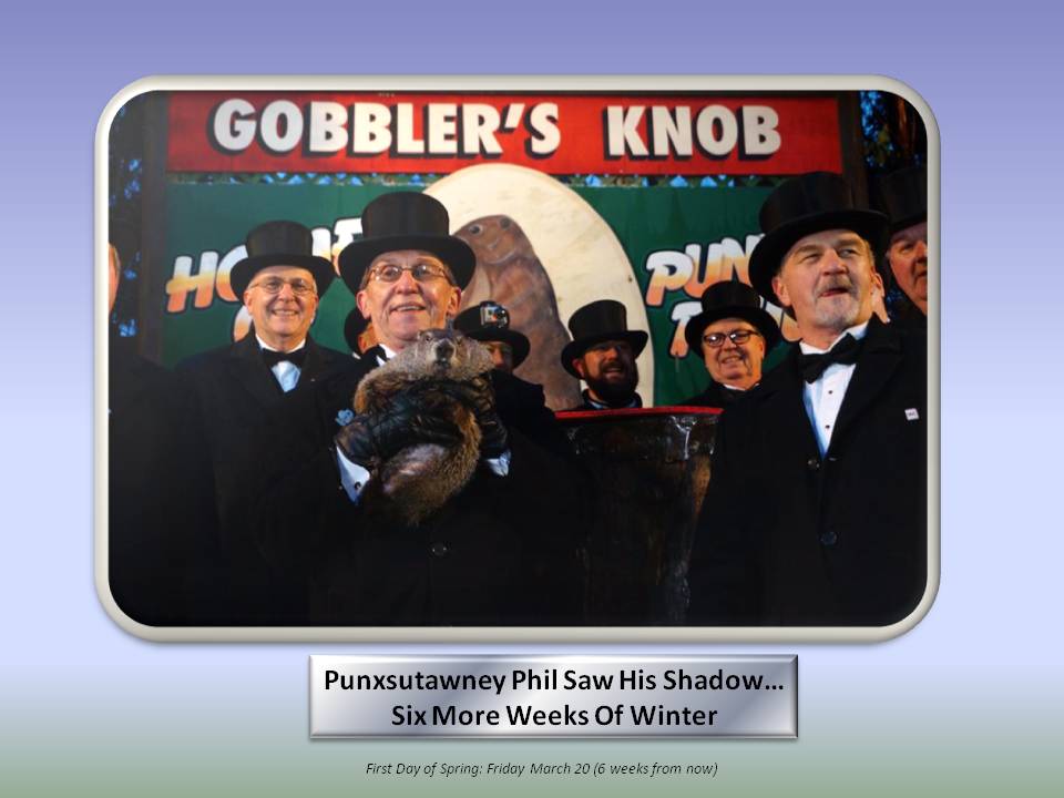
So Phil saw his shadow this morning. Great for Pennsylvania and a no-brainer, but what about the Piedmont?
Just for fun, we sent out a calendar of dates to watch for winter weather potential. Today was one of those and it has passed as a no-show (an all too common theme for us this winter). The next “opportunity” is Thursday and Friday.
A low pressure system from the gulf was originally forecast to enter the Carolinas about the same time as a strong High pressure system ushered in cold Canadian air. That High pressure is being modeled in the 1034 – 1038 mb range which models interpret by keeping our gulf Low further to the south. Further complicating the setup is a potent Low heading out to sea towards Greenland which has been shown in models to shear our Low apart.
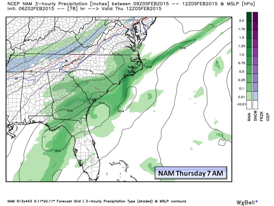
Map 1&2. The short-range NAM model clearly shows our Gulf Low passing over the Florida Panhandle and a long area in the NE section being sheared apart. Snow develops on the western slopes of the mountains as Canadian air filters in. This scenario is much drier than the other models but does agree that Friday will be much colder with highs only in the 30’s.
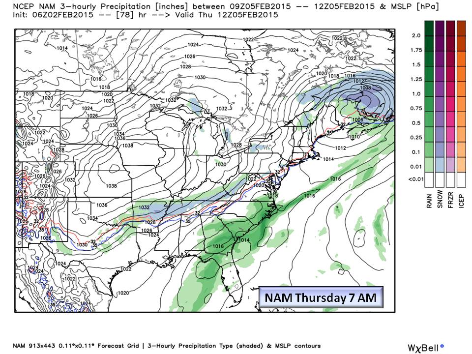
Map 3. The GFS for the same time shows how the 1037 mb High is keeping our Gulf Low further to the south while still allowing a shield of precipitation into the Piedmont. The timing here is critical as this scenario makes for a Wintry Mix in the Piedmont. There is not very much moisture associated with this scenario, but Friday anything that does fall overnight fall may freeze.
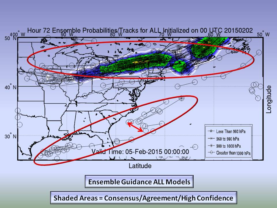
Map 4. How confident are we in the track of the Gulf Low? Not very. Shown here is the model spread among all Model ensemble members (sub models inside the larger model). Depending on the model, the strength of the Plains High pressure is determining how far south the Gulf Low stays. A weaker High will track the Low more northward. Not shown is the shearing environment absorbing the Low into the stronger NE system but that would happen after Piedmont passage.
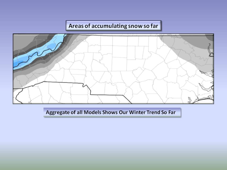
Map 5. We thought it would be interesting to put all models together beginning in November and show the pattern where Accumulating Snow has fallen in the Piedmont. This doesn’t account for freezing rain or sleet. Our mountains have had plenty and deformation bands have contributed to snow falling on our coastal plain…Mostly from last week’s system. Central NC is high and dry.
What the NWS Offices are saying:
- Raleigh:
THURSDAY...MODEL GUIDANCE IN DECENT AGREEMENT IN TRAVERSING A S/W IN THE SOUTHERN STREAM ACROSS THE NORTHERN GULF WED NIGHT WHILE A S/W
DIGS SEWD IN THE NORTHERN STREAM ACROSS THE LOWER OH VALLEY. THE STRONGER NORTHERN STREAM S/W EVENTUALLY CAUSES THE SOUTHERN STREAM
SYSTEM TO SHEAR OUT OFF THE SE U.S. COAST THURSDAY. THE TWO SYSTEMS WILL SPREAD VARYING DEGREES OF MOISTURE INTO CENTRAL NC LATE WED
NIGHT THROUGH THURSDAY. ANY PRECIP THAT OCCURS THURSDAY WILL BE LIGHT AND MAINLY CONFINED TO THE SE THIRD OF OUR FORECAST AREA.
PRECIP WILL INITIALLY FALL FROM CLOUD BASES 6000-8000FT SO IT WILL TAKE A WHILE TO SATURATE THE SUB CLOUD LAYER. THIS WILL LEAD TO SOME
EVAPORATIVE COOLING...SETTING THE STAGE FOR A POSSIBLE RAIN/SNOW MIX SCENARIO ACROSS THE NORTHERN PIEDMONT THURSDAY MORNING. (00Z GFS
BUFKIT SOUNDINGS DEPICT A POSSIBLE SEEDER FEEDER MECHANISM THURSDAY MORNING ACROSS THE PIEDMONT...AND ACROSS THE SANDHILLS AROUND MID
DAY).  STILL A LOT OF UNCERTAINTY WHETHER PRECIP WILL OCCUR THIS FAR NORTH. PLUS...MAY BE A CASE OF THE COLD AIR CHASING THE MOISTURE AS
BEST CAA OCCURS THURSDAY AFTERNOON (AT THE SAME TIME THE ATMOSPHERE UNDERGOES RAPID DRYING). FOR NOW WILL VARY POPS FROM SLIGHT CHANCE
ACROSS THE NORTHWEST HALF...TRENDING TO A 3:1 CHANCE ACROSS THE SE. HIGH TEMPS THURSDAY LOWER 40S NW TO THE UPPER 40S FAR SOUTH.
- Blacksburg:
RIGHT NOW…HAVE ONLY MODERATE CONFIDENCE IN THIS FORECAST. THE WEATHER FORECAST MODELS HAVE HAD NOT ONLY SIGNIFICANT DIFFERENCES WITH ONE ANOTHER CONCERNING THE TRACK AND THE IMPACTS OF THE LOW…THEY HAVE ALSO BEEN FLIP FLOPPING FROM THEIR PREVIOUS RUNS AS TO HOW THE LOW WILL BEHAVE. SO WILL STILL NOT HAZARD A GUESS AS TO HOW MUCH SNOW WE CAN EXPECT…EXCEPT TO SAY THAT THE WORST CASE SCENARIO PUTS ACCUMULATIONS AROUND THE LOW END OF ADVISORY CRITERIA.
- Greenville Spartanburg:
AS OF 220 AM MONDAY...AT 00Z THURSDAY A COLD FRONT WILL BE APPROACHING FROM THE NORTHWEST AND A LOW WILL BE TRACKING EAST ACROSS THE GULF
TOWARD FLORIDA. MOISTURE ASSOCIATED WITH THE FRONT IS RATHER SPARSE...ESPECIALLY ACCORDING TO THE ECMWF WHERE IT ONLY REACHES THE MTNS
DRYING UP AS IT CROSSES INTO THE FOOTHILLS ON THE EAST SIDE THURSDAY. VARIOUS MODELS HAVE THE GULF LOW PASSING CLOSEST TO OUR AREA THURSDAY
MORNING...WITH THE BEST FLUX OF MOISTURE ON THE ECMWF OVER PIEDMONT SECTIONS AROUND 12Z. HIGH PRESSURE BUILDS IN LATE THURSDAY FROM THE
NORTHWEST BRINGING BREEZY CONDITIONS UNTIL THE CENTER OF THE HIGH PASSES JUST NORTH OF OUR AREA LATE THURSDAY NIGHT AND ON FRIDAY.
THE HIGH SINKS SE TO BE ALIGNED FROM THE FLORIDA PANHANDLE TO THE CAROLINA COAST AT 00Z SATURDAY. THE COOL AIRMASS ASSOCIATED WITH
THE HIGH WILL BE MODIFYING FROM A FEW DEGREES BELOW NORMAL ON FRIDAY TO BEING NEAR NORMAL HIGH TEMPS OVER THE WEEKEND.
Bottom Line:
We have 6 more weeks of Astronomical Winter. Phil’s prognostication is more of a reason to party than predict the weather, but it’s still fun! Back here in the real world, we are seeing our now famous line “cold chasing rain”. However, our cold is much colder and more frequent this month with Arctic cold following our event Thursday. Here’s what we think will happen…
- Taking a blend of the GFS, NAM, and European we expect at most, Light rain on Thursday with a period of wintry mix possible as the front pulls out of the region. Thursday Night will be COLD with lows dipping into the teens in outlying areas so any precipitation that does fall may be a Black Ice issue Friday morning.
We have six more weeks of winter…teleconnections (the interaction between ocean currents and the atmosphere) show we will likely see winter lasting a bit beyond that. That topic is jargon laced, so we’ll spare you that!
NC Weather Happens. Enjoy it!
Be sure to get articles like this in your email by subscribing at ncwxhappens.com…its Free, No ads, and No spam but more importantly, No delay! We are also on Twitter @ncwxhappens.