
- Posted 7:30 PM 02/12/2015
- EXPIRES: 8:00 AM 02/16/2015
- Model Discussion with Forecast Possibilities
First, we are looking at BRUTAL cold with DANGEROUS Wind Chills this weekend. PLEASE make sure pets are protected from the elements. Sydney the Brown Weather Dog thanks you!

Official Forecast for Tuesday 2/17: Rain, Snow, Freezing Rain, and Sleet likely. Cloudy, with a high near 32. Chance of precipitation is 70%.
Yes this is conservative, and it has to be. Schools, daycare, business, government, and industry won’t listen to Bloggers or Social Media Forecasters… They base their decisions from official sources that use forecasts based on probability and today, it tipped at 30% that winter precipitation will happen Tuesday the 17th.
This article is designed to give you some insight on the tools forecasters use and why we think the way we do. Enjoy!
The Setup:
After an intense Siberian cold outbreak, the Piedmont is left with a dome of cold air Monday and Tuesday. Meanwhile a Baja California sourced Low traverses the Gulf coast and is expected to move up through the Carolinas and offshore becoming a nor’easter. Antecedent cold air still in place from this weekend’s polar outbreak remains and slowly pulls north about the same time as Gulf moisture arrives. The cold air departs the Piedmont to the Northeast while an in-situ cold air dam attempts to setup.
Yes this is a complicated scenario. It is not unprecedented though…to us, it spells Winter Mess!
Models are configured to show specific things…one of those is “Accumulated Snowfall”. You’ve seen them and they are shared all the time. We would share them if they turned out to be relevant!
Here is a worse case scenario for the Piedmont.
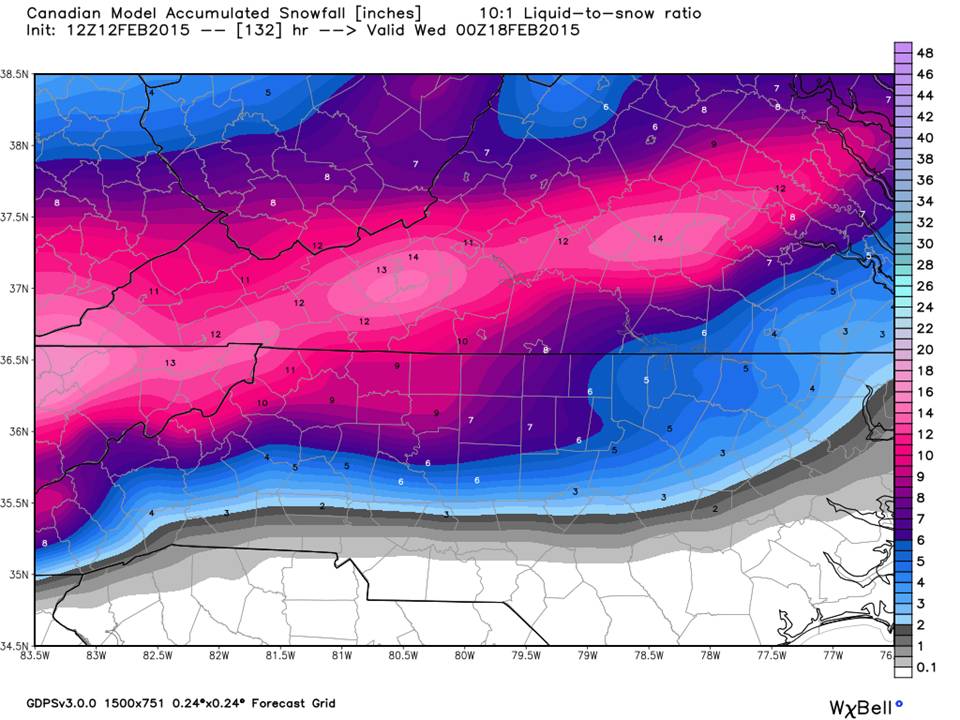
The European Model gives the Piedmont 10-14 inches of snow!!!
We think this will be a Wintry Mix for several reasons… First, the Gulf Low is intense funneling warm moist air into a departing cold High… overrunning (warm air advection) may be a problem. If cold air were in place bolstered by a strong high pressure over the Great Lakes, then we would have ample cold air supply and overrunning would not be a problem.
Soundings:


This is a BUFKIT Sounding of the GFS showing all the levels of the atmosphere as this system comes in. The Skew-T diagram is a screen shot of one segment at the storms onset, but gives an idea that other things are going on. The surface (ground temperature) will be very cold but a mile up in the air, warm air noses in…It will be snowing the beat the band at 7,000 feet, but it will melt and fall as freezing rain or sleet…At times, the warm air will pull back and everything will fall as snow.
The Canadian (and 14 inch European) don’t look so impressive now…
A profile of the Canadian, looks more like what we are talking about here…
Same moment in time, different perspective…
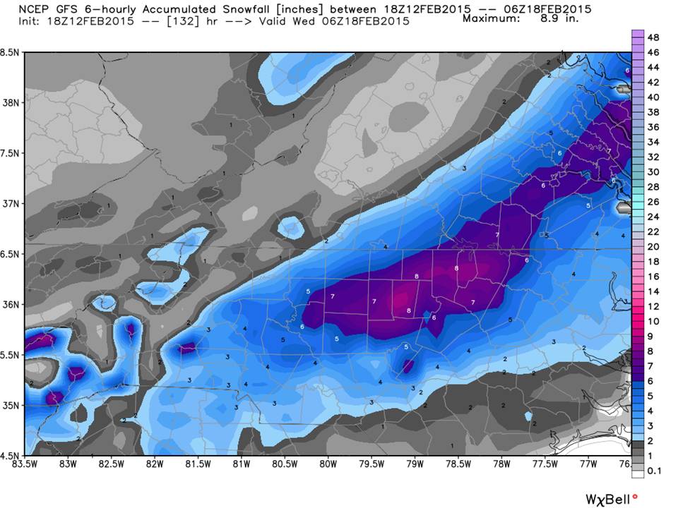
Let’s look at the GFS TOTAL ACCUMULATION: WOW!!!

WOW!!! 8 inches of snow!!!
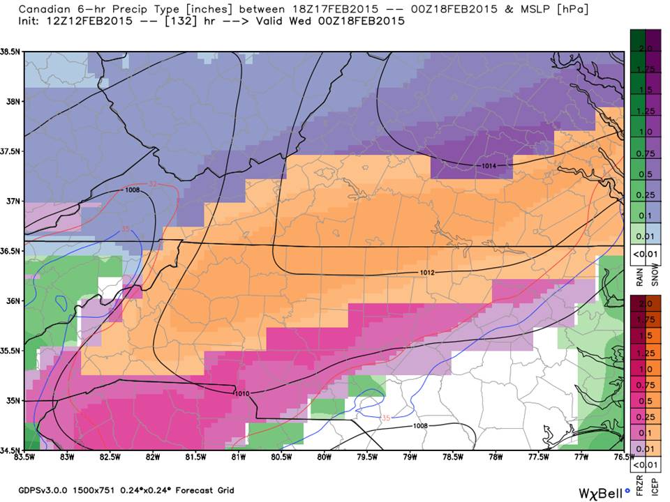
Break it apart and we see this…
A lot more ice than snow…
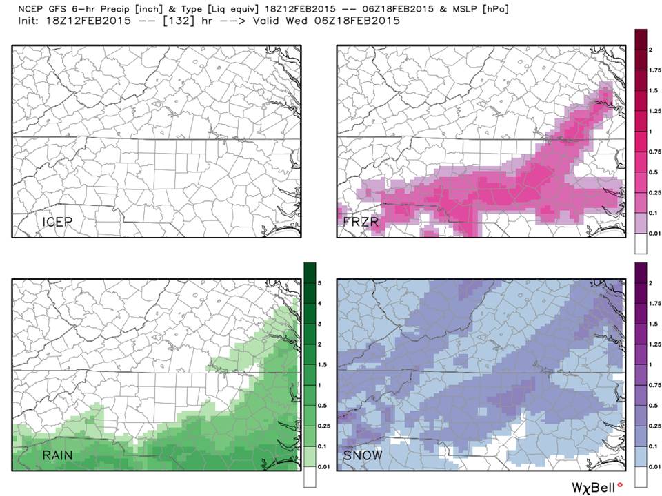
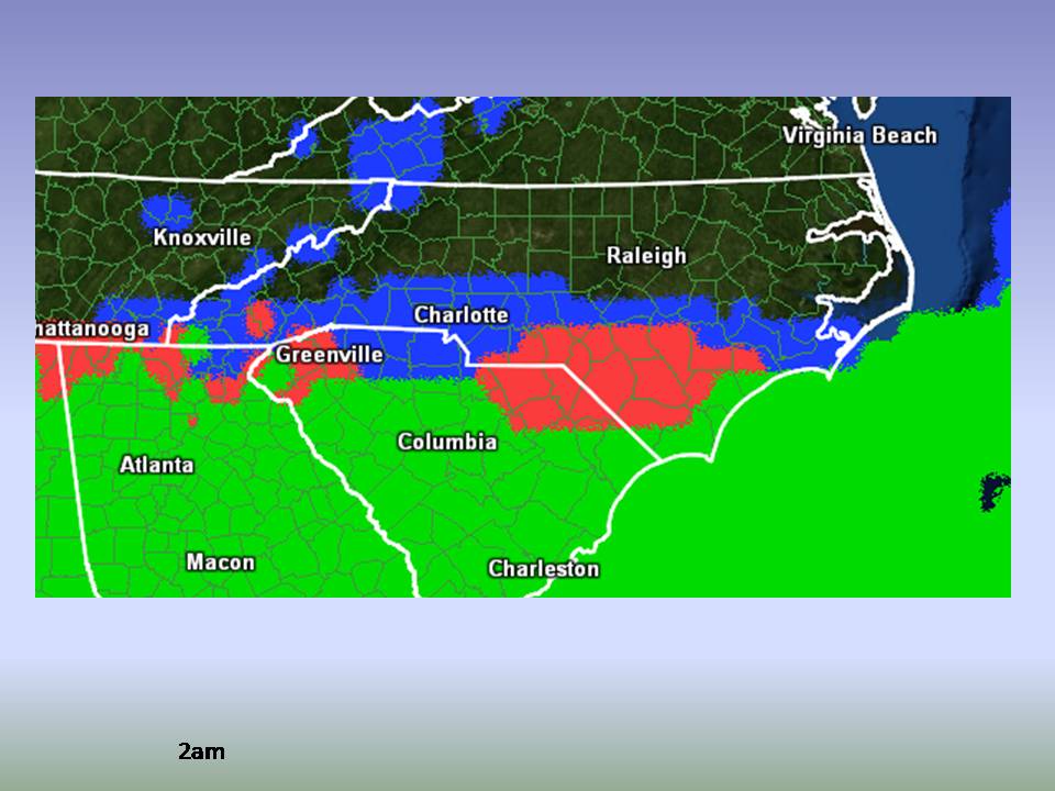
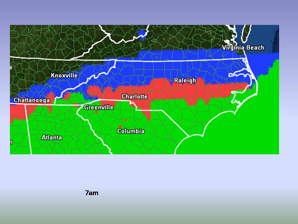
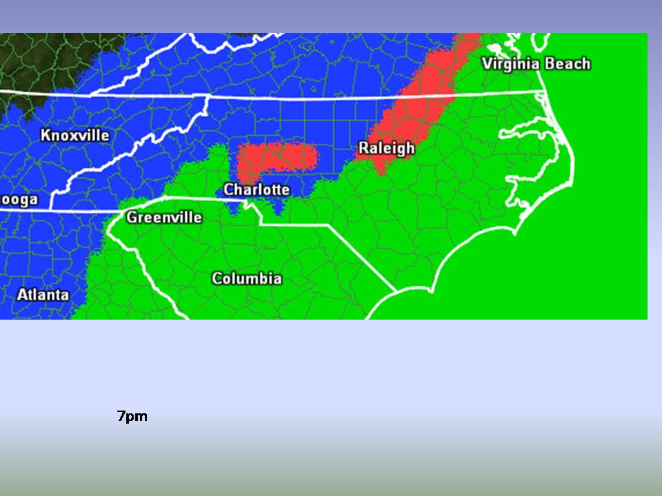
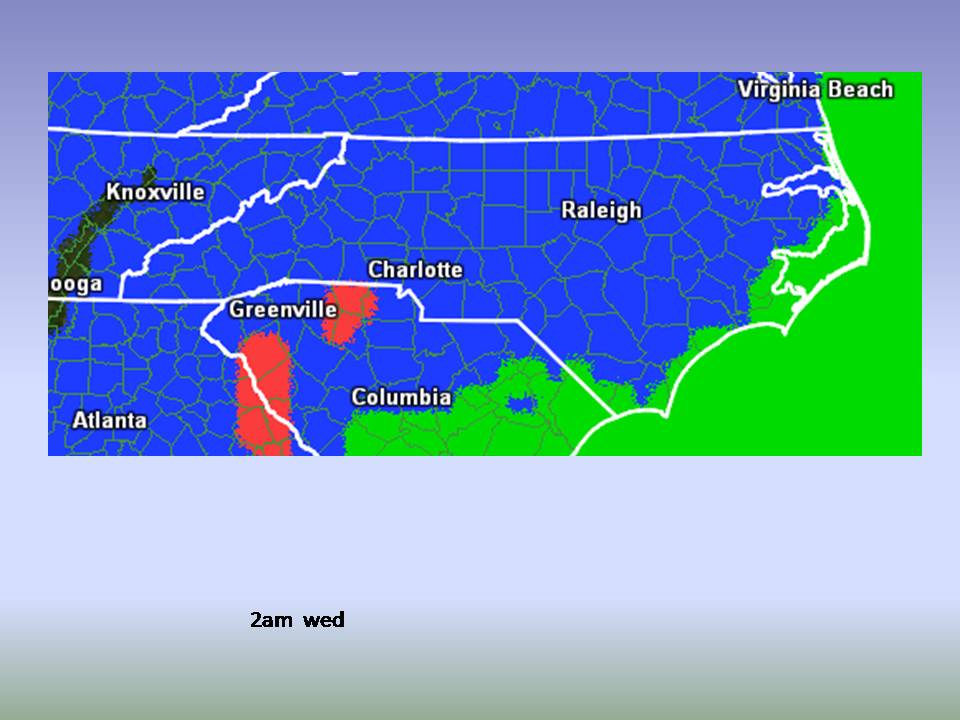
So let’s break it down by time and precipitation type:

Lastly, we love a Meteogram here at NC Weather happens!
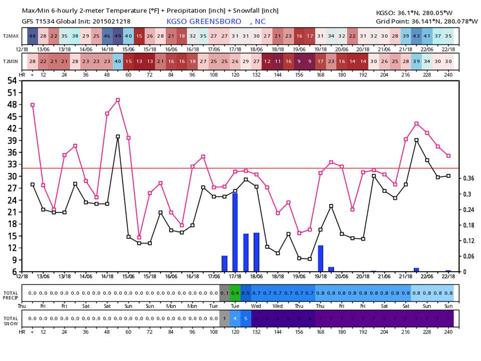
Shown here is the GFS for the next 10 days. It doesn’t account for thermal soundings, or climatology. What it does do is show one thing…we have an excellent chance for winter precipitation. This event is now inside of 5 days, so someone has to commit soon. We’ll go ahead and do that.
Based on what we see today, taking into account all trends in global models, the development of this Gulf Low (now showing up on the NAM), and Piedmont climatology, this is our forecast…
Beginning early Tuesday morning, flurries to light snow will begin with sleet mixing in at times. We could see a changeover to sleet and freezing rain with the heating of the day but with cloud cover temps should hover near freezing and freezing rain accumulation is a concern. Towards evening, we should see a change-over to snow lasting through daybreak Wednesday morning.
Too soon to discuss accumulations or anything more…this is just what we see today.
Bottom Line:
It’s probably a good idea to use the 40 degrees on Saturday afternoon to think about groceries. This is not an official “Milk and Bread Alert” but it’s still a good idea. Broadcast media is already making mention of this event as well as the NWS. Again, this is what both are looking at and now you know why we are leaning towards a winter mix…but it will likely be a significant winter mix with some accumulations. That can’t be resolved right now with the many variables still in play.
We hope this helps shed some light on the winter weather situation coming up. When we have some consensus on timing and strength, you will be the first to know!
NC Weather Happens. Enjoy it!
Be sure to get articles like this in your email by subscribing at ncwxhappens.com…its Free, No ads, and No spam but more importantly, No delay! We are also on Twitter @ncwxhappens.
If you are interested in advertising on this high volume webpage, please send us a note and we’ll send you some information.