
Cold Air Dam or Appalachian Wedge? Both mean cold
One of the primary reasons NC Weather Happens exists is because of this unique East Coast phenomenon.
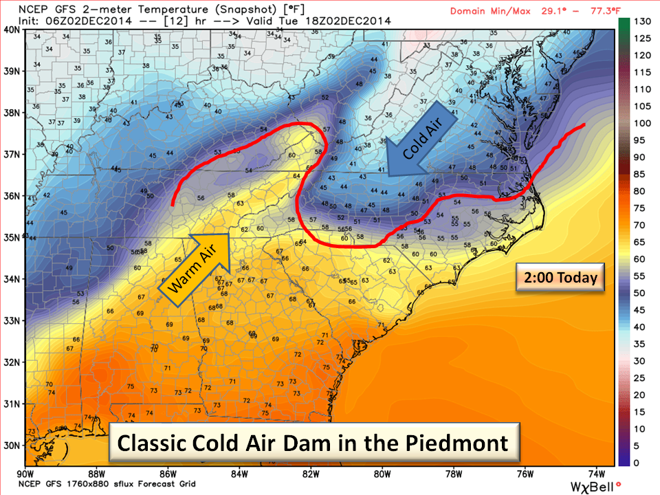
Here’s the setup: a strong High Pressure forms between the Great Lakes and New England. High’s rotate clockwise so they tend to bring that cold air down the eastern side of the Appalachians. The “wedge” term originated early-on as this cold air would “wedge” itself up against the mountains leaving the other side extraordinarily warm.
What does this mean for the Piedmont?
The Cold Air Dam or CAD, is one of the driving features that bring us wintry precipitation. If a moderate to strong CAD is in place when a coastal storm develops either in the Gulf of Mexico or off the Florida/Georgia coast, that counterclockwise rotation from the storm (Low) throws moisture into our cooler air. In the spring time, the CAD boundary is usually where severe thunderstorms flare up. So the CAD is vital in determining how our weather is going to shape up. The one problem we have is that they are extremely difficult to forecast as they vary by strength and duration.
So what’s the big deal?
Today is the first in a series of “Wedgies” with this being the strongest. There will be some fronts passing through this cooler air but there is no concern for winter precipitation at this time. The fronts are largely dry and this weekend the CAD will not be that strong to cool us off significantly. We also couldn’t resist showing you a classic scenario from the current weather.
Bottom Line:
Temps this morning will likely be the highs for the day. Light rain will be possible mostly this morning and this evening…same temps. We will see some mid 50’s later in the week and another raw rainy weekend. So that’s it for your Appalachian Wedgie Ed.
NC Weather Happens. Enjoy it!