
Will the Piedmont See a White Christmas in 2014?
Overview:
Without going into much jargon and techno-speak, here is what we are looking at. It’s all about ocean currents, their temperature, and how they interact with the atmosphere. Warmer than normal currents near Alaska in the Pacific, and Greenland in the Atlantic typically cause the interior of North America to become cooler. This also effects the Jet Stream and in this case, we have 2, the Northern and Southern streams. For us, a strong dip south with the southern stream allows warm and very moist air from the Gulf of Mexico to be transported inland…more typically, up the eastern coast. Insert Nor’easter here and then things start to make sense.
Now, my college professor would flunk me for this overview, but it “holds water”. Understanding Teleconnections and their influence on our local weather can be a full time job!
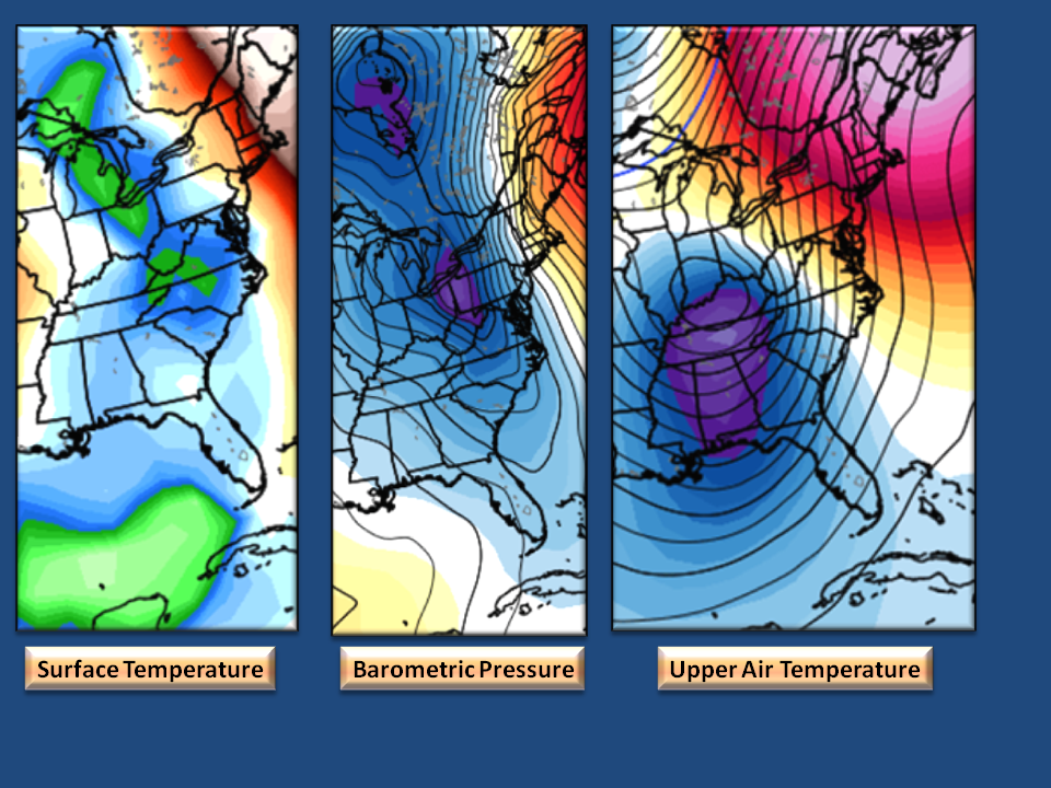
Surface Temperature:
Actually this is the 850 millibar temperature or the air temperature at about 5,000 feet up. We don’t live up there, so this is the best we can do in the long range.
Shown here is North Carolina and Virginia with temperatures about 6 degrees below normal. This doesn’t sound like much, but it is enough to suggest that here on the surface, it will be very cold the week of Christmas beginning on the 20th. This image depicts December 23rd.
So it will be Cold
Barometric Pressure:
Shown here is the Mean Sea Level Pressure (MSLP) which depicts a fairly strong Low Pressure system. also note the “U” shaped lines running through the state…this indicates a moderate Cold Air Dam setup…like what we just experienced. The large red area in the north Atlantic, is a potent High Pressure system. Note how close the lines are between the Red Area and the Blue Area…the closer they are, the more wind we will have. So, the 23rd is shaping up to be a Cold and Windy day…
Does that mean snow? The short answer is…pretty good chance of it! The origin of this low pressure system (not shown) is from the Gulf of Mexico which historically brings our best/worst snow events.
So it will be Cold, Windy, and something falling from the sky.
Upper Air Temperature:
This is actually the 500 millibar departure from normal temperature which is about 18,000 feet up. Again, we don’t live up there, so why is this important? This elevation is right below where the Jet Streams live so looking at temperature variations here aren’t affected by land conditions or the swift moving winds above. Good place to start! Last year, all those images you saw of the “Polar Vortex” came from this elevation…so…
Shown here we see another very, very cold outbreak. This particular cold airmass has it origins in the North Pacific and not the Arctic so we won’t be looking at brutal cold. In fact, brutal arctic air is typically very dry which lends the term “it’s too cold to snow”. That is not the case here. North Pacific cold airmasses tent to bring us down into the low 20’s. (A future discussion on Dew Point is needed).
So it will be Cold, Windy, Something falling from the sky, and very cold air aloft.
The Bottom Line:
From December 20th and running into the New Year, we see a pattern of atmospheric conditions setting up that will keep forecasters very busy. In our case, NC Weather Happens is NOT forecasting a White Christmas for the Piedmont…but we are forecasting an increasing likelihood that we may. That’s wishy-washy but we hope you can now see the variables required for it to happen and at the time of this writing, all the elements seem to be coming together correctly.
Now let’s start paying attention to the holidays as each model run and each observed measurement can change everything “on a dime”. Remember the long range is all about Ocean Currents, they are slow to change, and can be calculated quite accurately…how they interact with the atmosphere is where we have great difficulty. We hope that we were able to break this down into everyday English. 🙂
NC Weather Happens. Enjoy it!
Comments are closed.