
Looking at weather models through the second half of February, we have a pattern of cold and storminess setting up which usually doesn’t bode well for our state.
Taking one thing at a time…
Friday February 12, 2016:
A clipper dropping out of the Plains will mingle with a weak surface wave then develop and strengthen offshore before moving up the coast and out to sea. This is not a potent setup as these systems are usually moisture starved after crossing the mountains. At issue is that little disturbance it will run into which will introduce more moisture into our already cold air. Temperatures aloft and at the surface will be cold enough to support winter precipitation.
A winter mix is being illustrated in models from the Triad south and east. Snow changing over to sleet and freezing rain from the Triangle south and east. There is NOT much moisture for this system to work with however, so accumulations will be light from the Triad west. The coastal plain up into the Triangle stands the best chance of seeing measurable accumulation by Friday evening with roads likely becoming problematic.
As this is now showing up in Medium Range models, it is 7 days out so we will hold accumulation maps off as this is still a developing situation and I expect wide fluctuation in upcoming model solutions. Right now, keep the possibility of winter precipitation in your plans for Friday and Friday night.
Saturday the 13th through Monday the 15th:
COLD!!!
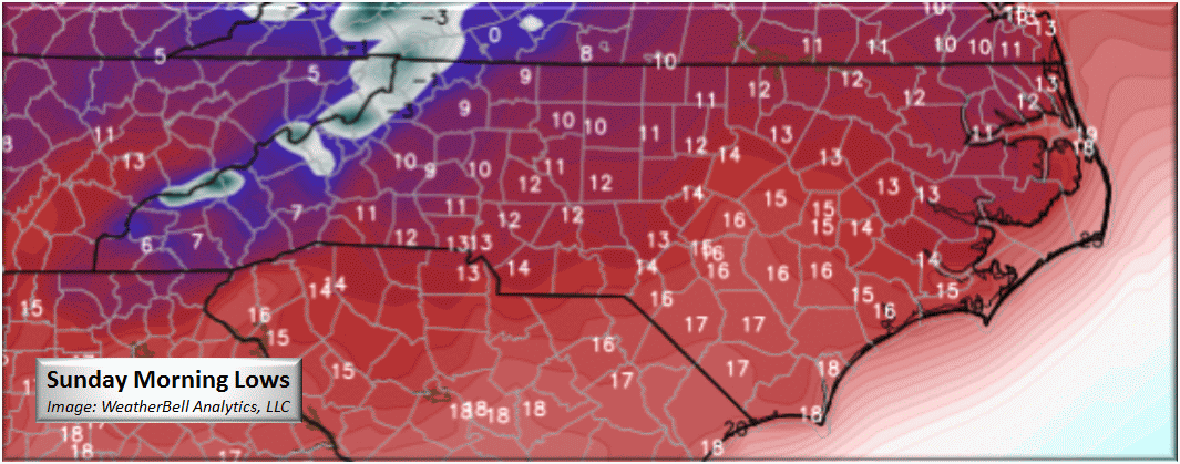
A very strong 1048 mb dome of Arctic high pressure will be situated over New England bringing in the coldest air of the season. Use this time to prepare for single digit morning temperatures and below freezing from Friday night into Monday possibly Tuesday.
Now what everyone wants to know about. When is it going to snow? I live in ____. what’s it going to do? This other site is saying SNOMYGOD…is that true? Well here’s the skinny on Monday through Tuesday Morning (15th and 16th).
This is inside of the 7 day forecast period so it must be mentioned, but there is still a lot of “waffling” going on with the various long-range models. Without much agreement in solutions, we try to find what is common. Right off, we can see that there will likely be a hybrid CAD event from a strong high pressure just offshore of New England. Our soil temperature will be in the upper 20’s and we have a developing low pressure system riding along the southern jet. This will be about timing unfortunately.
The European model has been trending warmer with each run and last evening was forecasting over a foot of all snow along and west of the I-85 corridor! This morning using the 850mb temperate as a guide (this model doesn’t distinguish precipitation type), areas west of I-85 stand to see accumulating snow while areas east sleet, freezing rain, and all rain on the coastal plain.
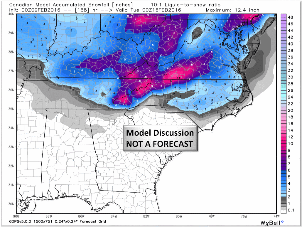
The Canadian is seeing the same thing but has been more consistent in an all snow solution for NC.
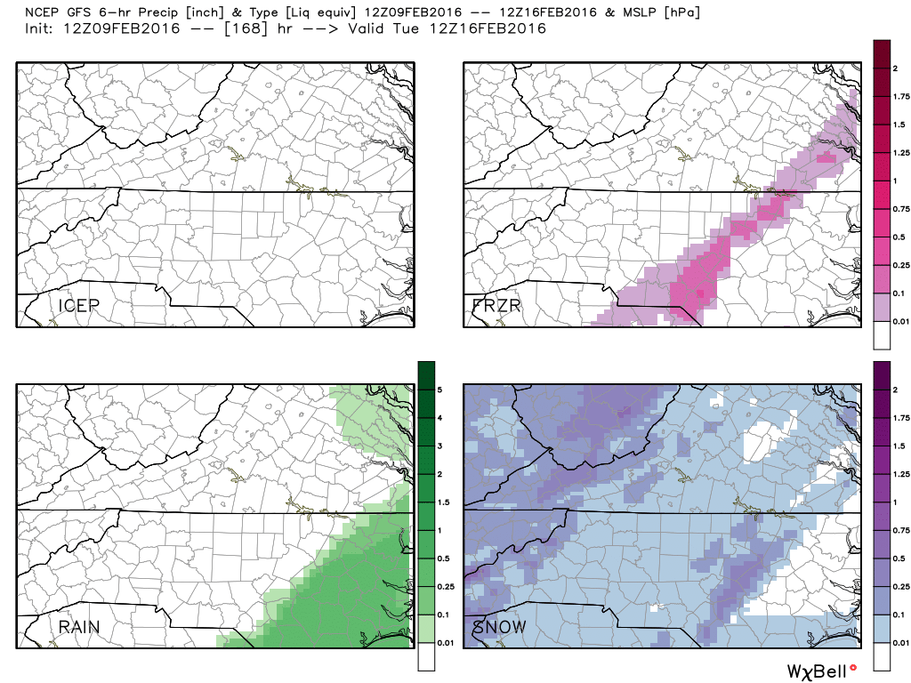
The GFS is the outlier with very little ensemble agreement.

The operational GFS however is trending more towards a winter mix solution for the middle of the state with Snow Freezing Rain being the predominate precipitation type from the SC and VA borders through the Triangle.
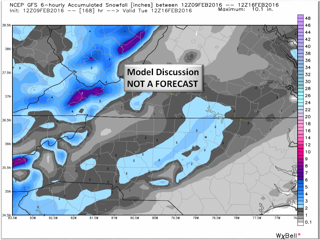
We’ve seen the Canadian snowfall solution…this is the latest GFS (American) solution for snowfall.
Bottom Line:
Taking one threat at a time, there is a small chance for a glaze of snow Friday afternoon and evening with isolated pockets in the Piedmont to and inch. The mountains can see 2-4 inches of snow so the ski slopes will be very happy. The more imminent threat will be Saturday through Monday morning with brutal arctic cold. This will be an extended duration event with temperatures not getting above freezing for 36+ hours. Last in our trio of threats is a looming wintry precipitation event Monday through Tuesday. This I not developing in an optimal teleconnection scenario, but timing may prove better than indices! As this is right at the edge of any forecast reliability, we are holding off with making predictions on accumulations or precipitation type at this time. Suffice it so say that IF this comes in as shown here, a significant winter weather event would unfold especially in areas receiving Freezing Rain.
So let the “what about my house” questions begin and we will update you with specific actionable information as we get closer to each event.
NC Weather Happens. Enjoy it!
Be sure to get articles like this in your email by subscribing at ncwxhappens.com…its Free, No ads, and No spam but more importantly, No delay! We are also on Twitter @ncwxhappens.
Advertise your business on this high volume webpage. Send us a note and we’ll send you some information.