
- Posted: 01/07/2015 7:15 pm
- EXPIRES 01/08/2015 6:00 pm
- Weather Discussion and NOT a Forecast
Weather Models shift Winter Weather Threat but Threat Remains.
As we saw yesterday, there was a potential Ice Storm Looming for this Sunday and Monday. Weather models have pulled back from an Ice Storm to virtually nothing but a slight Wintry Mix to all Rain. Why, and what does NC Weather Happens Local experience have to say about it?

Disclaimer: (or we need to cover this the best we can so we can keep food on the table comment):
The Setup:
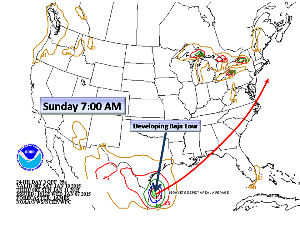
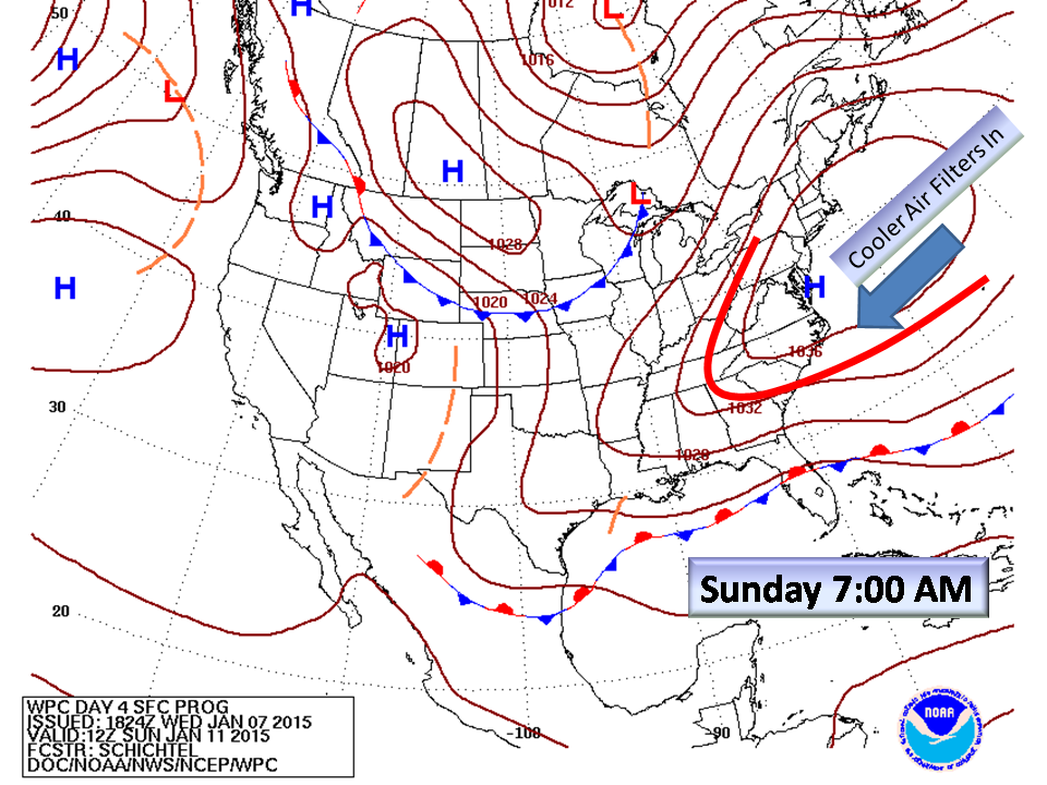
A 1040 millibar High pressure system will be in the favored New England region and travelling east to funnel cool air into the Piedmont (a Cold Air Dam). Meanwhile a Low Pressure coming out of Mexico into the Gulf will travel northeast through the Carolinas into the Atlantic.
Our Problem:
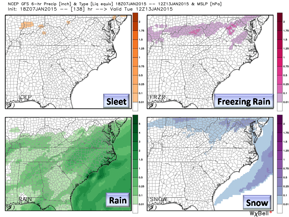
This is a warm Gulf air mass coming into a marginal cold airflow. Typically, this will give us a Freezing Rain/Sleet event. The Timing is the all important issue. IF the Gulf moisture arrives early in the day Sunday, it may transition into Freezing Rain. IF it arrives later, it will likely be all rain. The Cold Air Dam in place is weak at 1030 millibars and any clouds in place during the day, will keep the air warm through insolation. IF precipitation falls evaporative cooling will take place but will it be enough to drop the temperature? BUFKIT soundings indicate a warm-nose either way so any snow aloft will melt in the warm layer falling as sleet or freezing rain. Lastly, temperatures are forecast to be right at freezing so any fluctuation in temperature is important.
Here is what we think will happen:
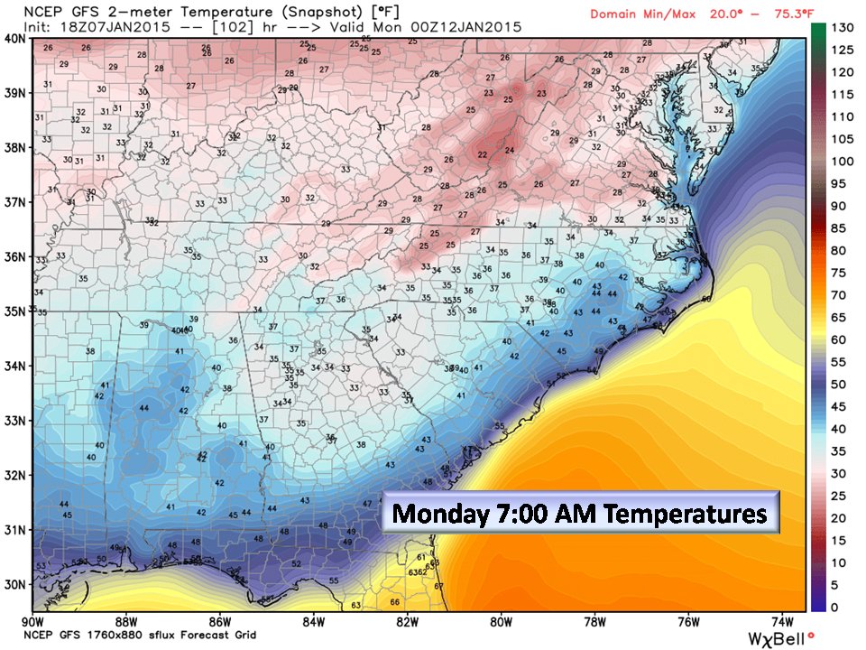
- Over night Monday, temps will fall to near freezing.
- We will have come out of a deep freeze, so ANY precipitation that does fall overnight will likely freeze once it hits the ground.
- The strength of the 1040 mb High is not in question, but its location is…the further east it moves, the more likely warm Atlantic air will warm the Piedmont up.
Other Factors (and some cool pictures):
From the latest Weather Discussion at the NWS… (Warning! Weather-speak follows):
For sun/Mon: the aforementioned wave moves NE from Texas and the northwest
Gulf toward the lower miss valley early sun... dampening out in the
process. But as the surface high centered to our north shifts east
and off the coast... the low-level influx of Atlantic-source
moisture from the Bahamas along with steadily increasing southern
stream influence and a sharpening northern stream jet will culminate
in increasing precipitation chances starting late sun or sun evening...
ahead of a weak northern stream front moving southeast of the Great Lakes
region. Precipitation at the ground may hold off until after the near-
surface layer has a chance to moisten from the middle levels on down...
with the onset of forcing for ascent due to improving upper
divergence and strengthening isentropic upglide. With a lack of DPVA
and a surface focus for lift... will keep probability of precipitation in the chance range
for now. Forecast soundings suggest that there may be enough cold
air locked in at the surface by the precipitation and evaporative cooling
such that there may be a risk for some patchy freezing rain at the
onset over the northern/western Piedmont. There is plenty of uncertainty
regarding how much near-surface cold air might be available with the
parent high having moved well offshore... although surface dew-point
will initially be quite low... bolstering the possibility of sub-
freezing wet bulbs. Will keep chances as just rain for now with
temperatures bottoming out above 32f... but will continue to keep an eye on
this potential. Expect daily highs no better than the 40s with
clouds and patchy precipitation limiting the diurnal range.
The Weather Service is even at odds with this as weather tools they use keep shifting. For the record, the weather service uses ALL models, local climatology, and even analogs to get a forecast out. This particular forecast period is EXTREMELY DIFFICULT!
The Bottom Line:
Remembering that this is just a discussion about the weather, NC Weather Happens would put a dollar down on a Wintry Mix Sunday night just because we feel the Cold Air Dam has been underestimated in the weather models. This is LOW confidence but as we have been saying all along…just keep it on your RADAR. Once short-range models sample the Baja Low and get a better handle on the High Pressure over New England Friday, we will know with some certainty.
Looking ahead, an active winter weather pattern is present so it’s all about that “timing issue”. Dates to consider for winter weather “opportunities”: 1/15 and 1/19 in the medium range. 1/29 in the long-range with another intense cold outbreak.
NC Weather Happens. Enjoy it!
Get articles like this in your email by subscribing at ncwxhappens.com or following us on Twitter @ncwxhappens.