
- Posted: 01/13/2015 3:30 pm
- Expires 10:00 pm
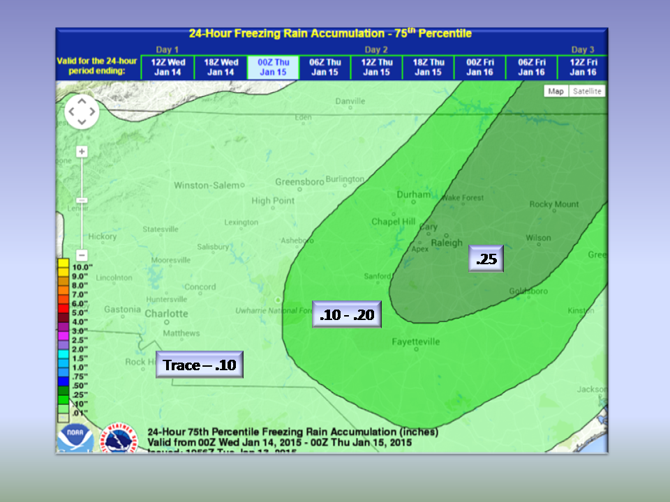
Northwest and Central Piedmont can expect generally a glaze to a tenth of ice. Areas East of the Triad up to 1/4 inch.
The area of precipitation coming in overnight is a bit farther offshore thus bringing generally lighter precipitation inland. We are still expecting travel issues Wednesday morning here so please check in with Local Media this evening before going to bed to see if there have been any late breaking updates.
At this time, this is what we could wake up to in the morning. This is a worst-case scenario so accumulations will generally be less than depicted.
Areas east of the Triad that were under a Winter Weather Watch have been downgraded to an Advisory.
..WINTER WEATHER ADVISORY REMAINS IN EFFECT FROM 7 PM THIS
EVENING TO NOON EST WEDNESDAY...

* LOCATIONS...WESTERN AND SOUTHERN PIEDMONT.

* HAZARD TYPES...FREEZING RAIN AND A LITTLE SLEET.

* ACCUMULATIONS...A LIGHT GLAZING IN THE NORTHWEST
  PIEDMONT...INCLUDING THE TRIAD AREA...TO UP TO A TENTH OF AN
  INCH OF ICE CLOSER TO THE US HIGHWAY 1 CORRIDOR.

* TIMING...THIS EVENING THROUGH WEDNESDAY MORNING WITH THE MOST
  SIGNIFICANT PRECIPITATION FALLING BETWEEN 1000 PM AND 400 AM.

* IMPACTS...HAZARDOUS TRAVEL CONDITIONS...ESPECIALLY ON BRIDGES
  AND OVERPASSES.

* TEMPERATURES...IN THE LOWER 30S.

* WINDS...NORTHEAST 5 TO 10 MPH WITH GUSTS UP TO 20 MPH.

PRECAUTIONARY/PREPAREDNESS ACTIONS...

A WINTER WEATHER ADVISORY MEANS THAT PERIODS OF FREEZING RAIN AND
SLEET WILL CAUSE TRAVEL DIFFICULTIES. BE PREPARED FOR SLIPPERY
ROADS AND LIMITED VISIBILITIES...AND USE CAUTION WHILE DRIVING.
Be safe and cautious in the morning before heading out and check your local media for any late breaking information.
NC Weather Happens. Enjoy it!